Field: Technology
NASA warns this year's Monster El Niño could be even bigger than legendary 1997 event
Published | Technical Staff
Visualization
In an alarming development for climatologists, NASA has identified an extraordinarily powerful El Niño brewing for the winter of 2026-2027, which could eclipse the infamous 1997-98 event often cited as the benchmark for extreme weather disruptions. Satellite data, the backbone of NASA's analysis, showcases striking parallels between the current anomaly and the historic episode that triggered catastrophic weather extremes globally. As researchers pore over 35 years of empirical satellite observations, they discern a potential for significant shifts in atmospheric patterns that could lead to severe rainfall and flooding, although the specific ramifications remain to be delineated.
El Niño, a recurring climate perturbation, manifests every two to seven years when sea surface temperatures elevate anomalously in the eastern and central equatorial Pacific Ocean, disrupting the prevailing atmospheric dynamics and consequentially altering global weather patterns. The 1997-98 and 2015-16 El Niños stand as titanic examples of this phenomenon, associated with severe droughts in Africa, devastating fires in Indonesia and the Amazon, and unprecedented flooding in Southern California. Now, scientists are attentively scrutinizing the 2026 El Niño as it emerges as yet another formidable contender in this pattern, with satellite evidence reinforcing the notion that it could rival its historic predecessors.
Understanding the intricacies of El Niño requires peeling back layers of oceanic and atmospheric interactions. Under typical conditions, robust trade winds perpetuate the migration of warm surface waters to the western Pacific, resulting in a higher sea level in that region. However, when these trade winds weaken, as is occurring presently, the warm water surges eastward. This shift catalyzes a feedback loop—whereby the advancing warm waters exacerbate the decay of the trade winds—raising sea levels and amplifying ocean temperatures across the eastern Pacific in a discernible manner.
The differences between El Niño episodes hinge on various factors, including the spatial distribution of warm water and atmospheric responses unique to each event, emphasizing that the quest for a definitive “typical” El Niño is inherently complex. Josh Willis, a project scientist from NASA's Jet Propulsion Laboratory, aptly notes, “The search for the ‘typical’ El Niño is very elusive. They're all different in terms of where they land and how their impacts play out.”
To elucidate the current state of the 2026 El Niño, scientists have revisited decades of ocean surface height data, employing satellite altimetry techniques that allow for a precise understanding of sea level variations across the Pacific. This methodology captures subtle alterations in ocean surface elevations, calibrated against the physical principle that seawater expands upon warming. High sea levels within the central and eastern Pacific unequivocally signify zones of heat accumulation during El Niño states.
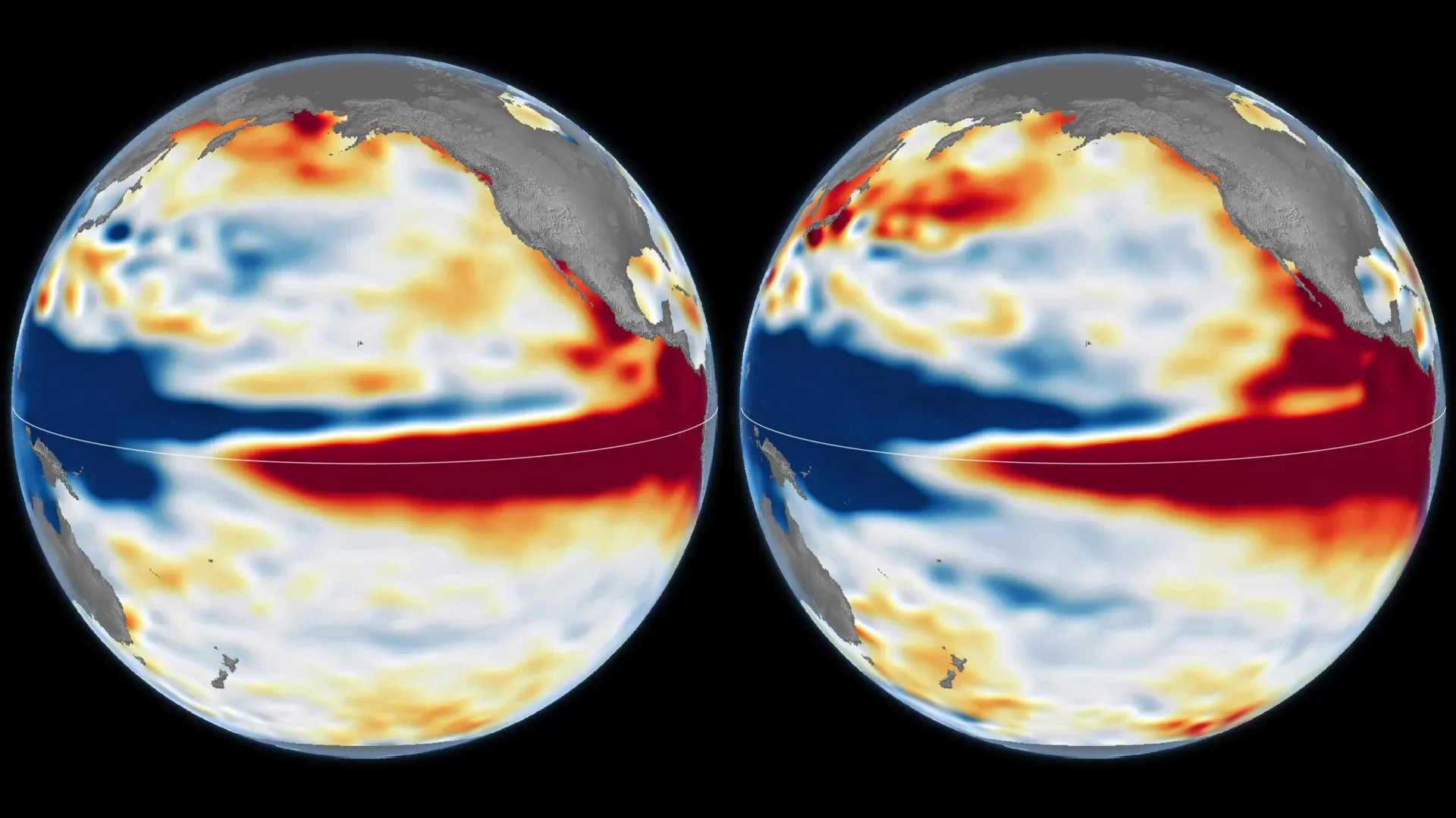
Recent comparative analyses, juxtaposing October 13, 1997, and October 12, 2026, reveal marked similarities in sea levels across the Pacific Basin. Pioneering research from NASA’s Sentinel-6 Michael Freilich satellite has been integrated into these assessments, providing an unbroken 35-year observational continuity critical for evaluating the characteristics of successive El Niño phenomena. Clear demarcation in sea level—red zones indicating elevated surfaces, white demonstrating average conditions, and blue denoting lower sea levels—offers insight into the sea surface dynamics at play.
This year's El Niño has manifested itself with greater rapidity compared to the gradual buildup seen in 1997-98, yet the core satellite observations depict substantial parallels in sea level discrepancies from west to east, with warmer waters extending along the equatorial path to the South American coastline. The potential for transformative atmospheric and weather patterns, akin to those experienced during the legendary 1997-98 El Niño, raises significant concerns as forecasters predict heightened precipitation events across California and potentially other southern U.S. regions this winter.
However, the comparison with the preceding 2015-16 event serves as a reminder that strength assessed through elevated sea surface temperatures does not yield analogous weather outcomes. Even as the 2015-16 El Niño demonstrated elevated temperatures and ocean levels, the distribution of warmth towards the Peruvian coast was not as pronounced, leading to distinct precipitation patterns concentrated elsewhere, notably over Central America and southern states.
As climatologists endeavor to predict the forthcoming effects of the 2026 El Niño, the specter of uncertainty remains. The National Oceanic and Atmospheric Administration (NOAA) recently projected an 83 percent probability of enduring strong to very strong El Niño conditions into early 2027. Yet, even profound analogs like the 1997 event cannot assure over how these atmospheric changes will cascade globally, especially as they reach farther temperate regions where additional meteorological phenomena can distort traditional predictive models.
“There's always a bit of a dice roll here,” Willis asserts, highlighting the unpredictable nature inherent to these climatological phenomena. Thus, as we stand on the precipice of a potentially unprecedented El Niño, the scientific community remains vigilant, poised to unravel the potentially dramatic tapestry of global weather woven by this evolving climate giant.
El Niño, a recurring climate perturbation, manifests every two to seven years when sea surface temperatures elevate anomalously in the eastern and central equatorial Pacific Ocean, disrupting the prevailing atmospheric dynamics and consequentially altering global weather patterns. The 1997-98 and 2015-16 El Niños stand as titanic examples of this phenomenon, associated with severe droughts in Africa, devastating fires in Indonesia and the Amazon, and unprecedented flooding in Southern California. Now, scientists are attentively scrutinizing the 2026 El Niño as it emerges as yet another formidable contender in this pattern, with satellite evidence reinforcing the notion that it could rival its historic predecessors.
Understanding the intricacies of El Niño requires peeling back layers of oceanic and atmospheric interactions. Under typical conditions, robust trade winds perpetuate the migration of warm surface waters to the western Pacific, resulting in a higher sea level in that region. However, when these trade winds weaken, as is occurring presently, the warm water surges eastward. This shift catalyzes a feedback loop—whereby the advancing warm waters exacerbate the decay of the trade winds—raising sea levels and amplifying ocean temperatures across the eastern Pacific in a discernible manner.
The differences between El Niño episodes hinge on various factors, including the spatial distribution of warm water and atmospheric responses unique to each event, emphasizing that the quest for a definitive “typical” El Niño is inherently complex. Josh Willis, a project scientist from NASA's Jet Propulsion Laboratory, aptly notes, “The search for the ‘typical’ El Niño is very elusive. They're all different in terms of where they land and how their impacts play out.”
To elucidate the current state of the 2026 El Niño, scientists have revisited decades of ocean surface height data, employing satellite altimetry techniques that allow for a precise understanding of sea level variations across the Pacific. This methodology captures subtle alterations in ocean surface elevations, calibrated against the physical principle that seawater expands upon warming. High sea levels within the central and eastern Pacific unequivocally signify zones of heat accumulation during El Niño states.
Recent comparative analyses, juxtaposing October 13, 1997, and October 12, 2026, reveal marked similarities in sea levels across the Pacific Basin. Pioneering research from NASA’s Sentinel-6 Michael Freilich satellite has been integrated into these assessments, providing an unbroken 35-year observational continuity critical for evaluating the characteristics of successive El Niño phenomena. Clear demarcation in sea level—red zones indicating elevated surfaces, white demonstrating average conditions, and blue denoting lower sea levels—offers insight into the sea surface dynamics at play.
This year's El Niño has manifested itself with greater rapidity compared to the gradual buildup seen in 1997-98, yet the core satellite observations depict substantial parallels in sea level discrepancies from west to east, with warmer waters extending along the equatorial path to the South American coastline. The potential for transformative atmospheric and weather patterns, akin to those experienced during the legendary 1997-98 El Niño, raises significant concerns as forecasters predict heightened precipitation events across California and potentially other southern U.S. regions this winter.
However, the comparison with the preceding 2015-16 event serves as a reminder that strength assessed through elevated sea surface temperatures does not yield analogous weather outcomes. Even as the 2015-16 El Niño demonstrated elevated temperatures and ocean levels, the distribution of warmth towards the Peruvian coast was not as pronounced, leading to distinct precipitation patterns concentrated elsewhere, notably over Central America and southern states.
As climatologists endeavor to predict the forthcoming effects of the 2026 El Niño, the specter of uncertainty remains. The National Oceanic and Atmospheric Administration (NOAA) recently projected an 83 percent probability of enduring strong to very strong El Niño conditions into early 2027. Yet, even profound analogs like the 1997 event cannot assure over how these atmospheric changes will cascade globally, especially as they reach farther temperate regions where additional meteorological phenomena can distort traditional predictive models.
“There's always a bit of a dice roll here,” Willis asserts, highlighting the unpredictable nature inherent to these climatological phenomena. Thus, as we stand on the precipice of a potentially unprecedented El Niño, the scientific community remains vigilant, poised to unravel the potentially dramatic tapestry of global weather woven by this evolving climate giant.